

Plant ecology and soil characteristics of a Midwestern bluff prairie
What we call the South Slope is a classic Midwestern bluff
prairie. A few years ago (2014) Peter Hartman and crew from the USDA-NRCS came
and studied our South Slope as part of their work to develop a “site description” for bluff
prairies.
Our South Slope is part of what the NRCS calls the Northern
Mississippi Valley Loess Hills, a region which includes parts of four states:
Wisconsin, Iowa, Minnesota, and Illinois. Two other terms sometime used are the
“Driftless Area” and the “Paleozoic Plateau”. The latter term is used because
the bedrock formations are from the Paleozoic Era, sedimentary dolomites and
sandstones from the Ordovician and Cambrian Periods.
The soils were formed during the 450-500 million years since
the rocks were first laid down, and then were followed during the last
(Wisconsin) glaciation by a layer of fine silt (loess). This loess layer was laid
down during a xeric period after the glacier had receded (10-15,000 years ago).
Most importantly, the steep bluffs are covered by colluvium, a term which describes the loose
rocky fragments that move downslope either by rainfall or by slow down-slope
“creep”. These extremely rocky soils are
called sometimes called flaggy (like being derived from flagstone), channery
(with flat coarse fragments) or cobbly (rounded stones). These are more refined
terms for soils I have always just called “rocky”.
The rocks and other fragments derived from bedrock are
especially obvious after a burn.
I had always assumed that if our soils were so rocky that bedrock
was right below the surface, so there was essentially no soil at all. Wrong!
The soil layer is many feet thick!
The photo shows the site crew at work. Note the tall thin
rod with a handle at the top. One of the crew members actually inserted that
rod into the bluff all the way up to the hilt, five feet. Indeed, according to
the site description, these soils are 4-5 feet thick.
 |
| Peter Hartman and his NRCS crew working on the South Slope (Unit 1) on June 3, 2014. Note the long rod with handle, standing to the right. This rod was later pushed vertically right up to the handle. |
 |
| The rocky soil after a burn. Most of the rock fragments are derived from the dolomite bedrock up-slope. Not all the surface is this thick with rocks. The thick soil layer can be found below and between the rocks. Grasses like little bluestem and forbs can grow between the rocks, sending their roots deep into the soil. March 26, 2010 |
 |
| Little bluestem bunches just starting to grow, South Slope (Unit 5), April 11, 2016. The Slope was burned on March 11, 2016. |
 |
| Late summer lush little bluestem bunches growing out of the rocky South Slope soil. Sept 27, 2016. |
 |
| Cross section of part of a typical bluff prairie habitat. The South Slope bluff at Pleasant Valley Conservancy has another layer (Tunnel City Sandstone) below the St. Lawrence Dolomite. Source |
When walking uphill across the South Slope, one crosses over four
bedrock layers. Because it is at the top of the hill,
the dolomite layer is the most important. In fact, dolomite rock fragments can
eventually find there way all the way down the hill. Although loamy (from the
loess), they may contain more than 35% rock fragments. These soils are
excessively well-drained, so there is never a zone where water is saturated.
“Typically, on these dolomite sites, the loess and dolomite
rock fragments are thoroughly mixed.” The soil is generally alkaline (pH
greater than 7). At PVC I have found soil pH values as high as pH 8-8.5
Typical plants on the
dolomite slope.
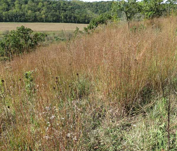
Consistent with the general description by the NRCS, our
South Slope is covered by large, open prairie. Breaks in the slope, due to
changes in the underlying bedrock, may alter the species. The most common
species are little bluestem and Indian grass, with scattered forbs across the
site.
It is well established that the vegetation of these bluff prairies
depends strongly on frequent fire. Without fire the sites gradually become
brushed in and/or covered with red cedar. The bluff prairie plants cannot
tolerate shade, especially that from the dense red cedar cover, and quickly
disappear.
Historically, these dolomite slopes were burned frequently,
which maintained the prairie and prevented the invasion by woody plants. Out
restored South Slope is burned annually.
 |
Although prairie grass predominates, there are always flowering forbs on the South Slope. Unit 3, Aug 9-2011.
 |
Early fall view of the South Slope. Depending on the amount of summer rain, the grass may be either little bluestem (dry years) or Indian grass (moister years). Unit 3/3A 9-22-2014
1 Comments:
One interesting observation about correlation between vegetation and soils in my area (La Crosse, WI). The main place I find jeweled shooting star (Primula fassettii) and white camas (Anticlea elegans) is at the "outcrop ledge or cliff" area shown on your diagram.
Post a Comment
Subscribe to Post Comments [Atom]
<< Home