Burn at Black Earth Rettenmund Prairie
Black Earth Rettenmund Prairie State Natural Area is one of the treasures of The Prairie Enthusiasts and has been under intensive management since TNC first bought the property over 25 years ago. Kathie and I have been the stewards and have managed the burns since 2001. By current standards, Rettenmund is a small site (16 acres), but it is a lovely site, and very easy to visit.
The prairie consists of a fairly high NE/SW trending gentle ridge which slopes off both east and west, where alfalfa fields are present. Because there is no corn stubble, there is no problem with spotting outside the burn unit.
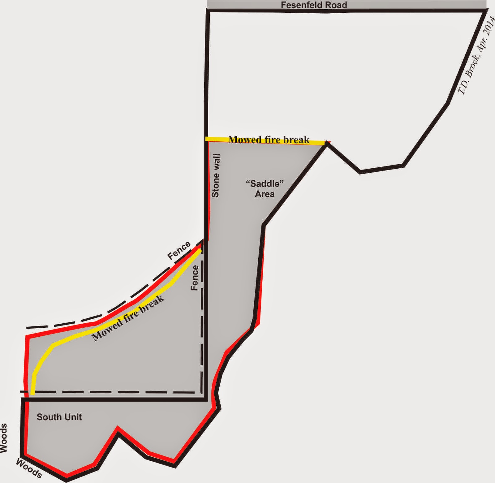
The site is divided into three burn units, North, Saddle, and South, and two of the three units are generally burned each spring. The darker gray area on the map shows what was burned this year.
Just north of the South unit is a small unused pasture owned by a neighbor. The fence, shown in dashed lines, divides the private pasture from the South unit. In order to have better control of the burn, since the days of TNC management the pasture and South unit are burned together (with the neighbor's permission). The fire break that Kathie mowed along the north edge of the pasture is shown in yellow.
We generally burn Rettenmund in late March but problems this year, mainly weather, kept this from happening. Finally, near the end of April everything gelled and we were able to get the burn done last Saturday (April 26, 2014). Amanda took responsibility for organizing everything and lining up the crew (10 people).
The wind was out of the northeast, so the burn started at the SW fence corner. One burn line was north of the fence in the pasture, the other south of the fence in the prairie. The pumper unit in our Kawasaki Mule was used to wetline along the mowed fire break through the pasture. (Access to the pasture is by way of a chained gate at the north end of the pasture.) Because this pasture is the high point (see photos below), it was burned first and the south burn line held back. Once the pasture was black, the south line could move faster. The two lines eventually met at the middle of the north fire break, where a brief head fire ended the burn. (Each person had a radio, essential here because the two lines were out of sight of each other throughout the whole burn.)
 |
| The north burn line has just exited the pasture, The green at the bottom of the photo is the neighbor's alfalfa, which was not burned. Photo: Kathie Brock |
 |
| After the burn. Looking south into the Saddle from the North unit. The pasture is the black area in the distance. The invisible South unit is behind and downhill from the pasture. Photo: Kathie Brock |
Despite the small size of the burn (7 acres), it took 2 hours to complete, and every person involved kept busy the whole time.
An interesting side result of burning the pasture: Fire alone has resulted in the conversion of this pasture into a little bluestem prairie, with scattered forbs (butterfly weed, wood lily)!


0 Comments:
Post a Comment
Subscribe to Post Comments [Atom]
<< Home