

Soils map via GIS
The USDA now has all their soils maps on line and they are available for download in a format suitable for GIS. Since it is raining today, I have been spending some time preparing a version that can be used for vegetation analysis.
Here is a link to the NRCS web soils home page. When that page opens you click on the big green button that says Start WSS. This opens a US map plus a lot of options for zeroing in on your own property. I put in our address: 4609 Pleasant Valley Road, Black Earth, WI 53515, and a fairly high resolution photo of the Conservancy opened. (If you have the zip code you don't need the rest of the village and state data.) There are a lot of options for navigating, etc., but the main thing is to select an Area of Interest (AOI). You outline your area in a red rectangle or polygon, let up the mouse, and within a few seconds a cross-hatched overlay of the air photo is displayed.
There are several tabs at the top, one of which says "Soil Map". Click on this and you get a soil map overlay of the air photo, with symbols for the various soil types. Also given to the left is a table which explains what each of the symbols means. For each soil type there is a link which will open up a detailed table describing that soil type. In addition, data are given on the percentage of each soil type in your AOI.
In essence, almost all the information that is available in the fat book entitled "Soil Survey of Dane County" is given on this web site. It is reasonably user friendly and works like a charm. There are also options for printing either the tabular data or the map.
For GIS you can download the soils data, including the soil contour map (called "spatial data"). When you click on "Download Soils Data" you get a pop-up window that gives you choices, among which is the very important georeferencing coordinates for your area. There is a box where you fill in your email address. Then click "Download data". The program will then create the files that you requested and will notify you by email when they are ready. When I did this I got a message saying that there were four people ahead of me in the queue. Within less than ten minutes I had an email message which provided a link to the location of the zip file on the web server. The file contained a number of subfiles, including various shape files, readme files, tabular data, and some explanatory material.
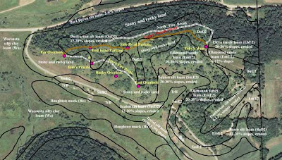
After a few false starts, I was able to bring the soil map into ArcGIS and overlay it on my 2008 air photo. Mainly I was interested in the contours of the various soils. Then, using ArcGIS software, I labeled the soils, and added some of my own waypoints and tracks.
The map shown below is a version that is greatly reduced in resolution (72 dpi) so that it can be uploaded quickly. The version I created is 300 dpi and can be printed at high resolution on a good color printer. I'd be happy to send by email the 300 dpi version to anyone who wants it.
Now that I have this soil map in ArcGIS, I can start doing some vegetation analysis.
Here is a link to the NRCS web soils home page. When that page opens you click on the big green button that says Start WSS. This opens a US map plus a lot of options for zeroing in on your own property. I put in our address: 4609 Pleasant Valley Road, Black Earth, WI 53515, and a fairly high resolution photo of the Conservancy opened. (If you have the zip code you don't need the rest of the village and state data.) There are a lot of options for navigating, etc., but the main thing is to select an Area of Interest (AOI). You outline your area in a red rectangle or polygon, let up the mouse, and within a few seconds a cross-hatched overlay of the air photo is displayed.
There are several tabs at the top, one of which says "Soil Map". Click on this and you get a soil map overlay of the air photo, with symbols for the various soil types. Also given to the left is a table which explains what each of the symbols means. For each soil type there is a link which will open up a detailed table describing that soil type. In addition, data are given on the percentage of each soil type in your AOI.
In essence, almost all the information that is available in the fat book entitled "Soil Survey of Dane County" is given on this web site. It is reasonably user friendly and works like a charm. There are also options for printing either the tabular data or the map.
For GIS you can download the soils data, including the soil contour map (called "spatial data"). When you click on "Download Soils Data" you get a pop-up window that gives you choices, among which is the very important georeferencing coordinates for your area. There is a box where you fill in your email address. Then click "Download data". The program will then create the files that you requested and will notify you by email when they are ready. When I did this I got a message saying that there were four people ahead of me in the queue. Within less than ten minutes I had an email message which provided a link to the location of the zip file on the web server. The file contained a number of subfiles, including various shape files, readme files, tabular data, and some explanatory material.
After a few false starts, I was able to bring the soil map into ArcGIS and overlay it on my 2008 air photo. Mainly I was interested in the contours of the various soils. Then, using ArcGIS software, I labeled the soils, and added some of my own waypoints and tracks.
The map shown below is a version that is greatly reduced in resolution (72 dpi) so that it can be uploaded quickly. The version I created is 300 dpi and can be printed at high resolution on a good color printer. I'd be happy to send by email the 300 dpi version to anyone who wants it.

Now that I have this soil map in ArcGIS, I can start doing some vegetation analysis.
0 Comments:
Post a Comment
Subscribe to Post Comments [Atom]
<< Home